Test

Certified B Corporation — Adaptive Retrofit — Humanising Infrastructure — Making better places — Architecture — Public Realm — Spatial Strategy — Creative Reuse — Urban Transformation — Decarbonisation —

Thamesmead to Barking River Crossing— London

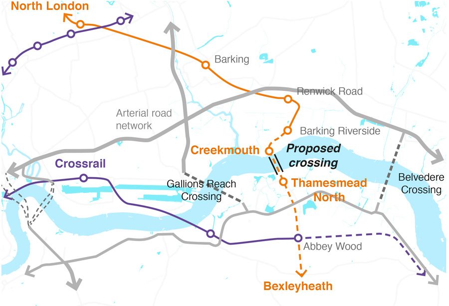
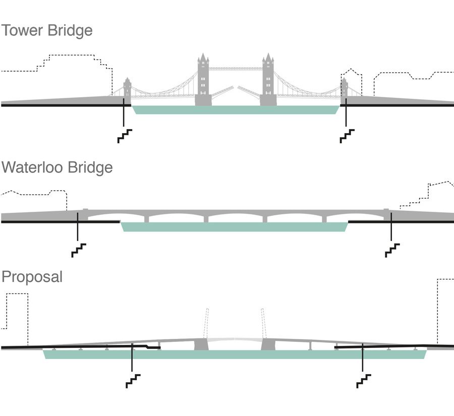
The need for additional river crossings east of Tower Bridge is well-acknowledged, and forms part of Mayoral policy. The scale of the Thames in the Estuary demands very long bridges, that tend to be associated with national-scale highways, bringing with them all the additional disturbance and pollution of mass road traffic and making plans for such infrastructure unpopular.

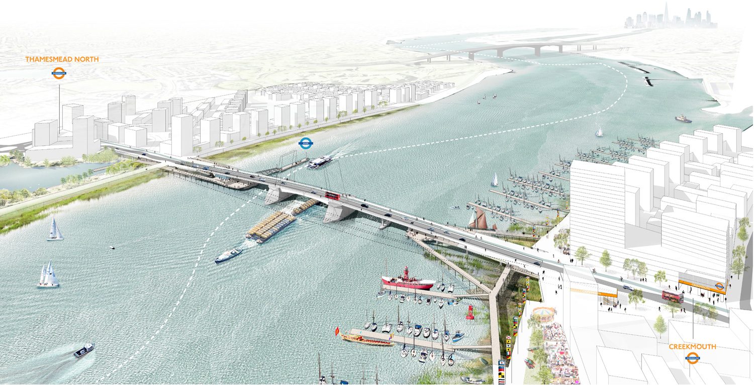
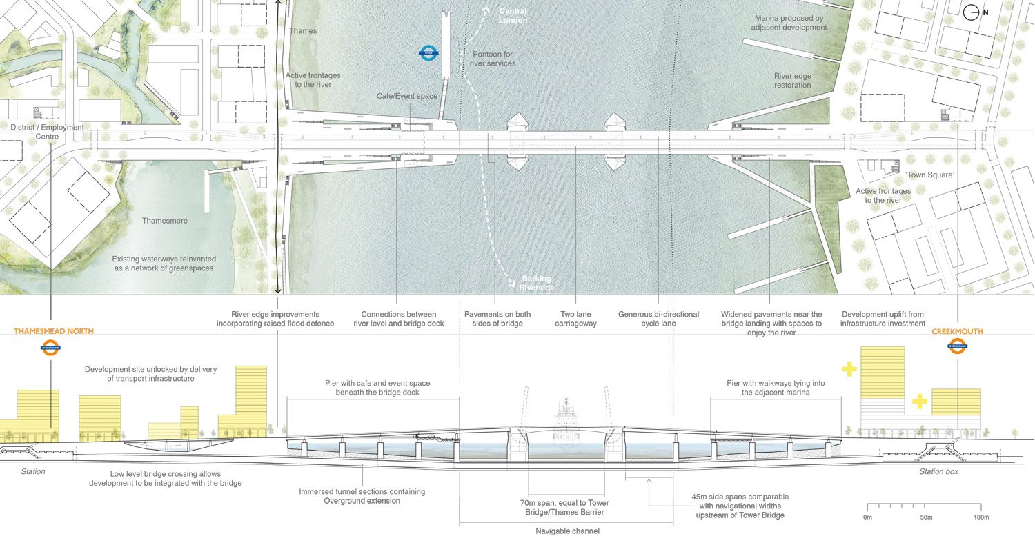
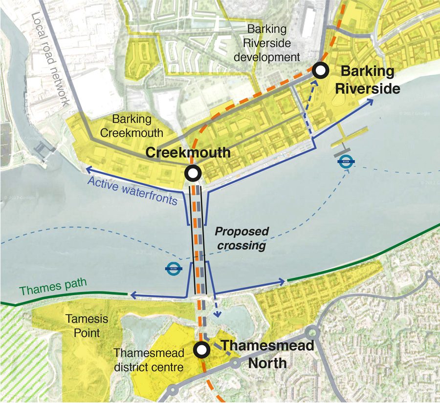
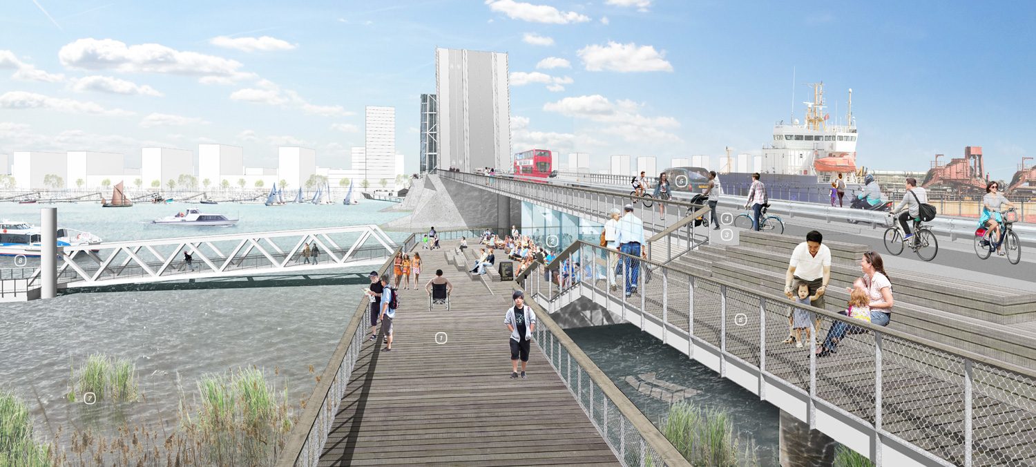
We propose an alternative, more local approach, that ties together the complementary riverside settlements of Barking and Thamesmead and provides value through ensuring that the infrastructure plays multiple roles: unlocking latent development, providing new active transport connectivity and ensuring that the bridge itself acts as a place of exchange.

A proposed new cross-river ‘productive town-centre’ would serve to stitch together currently disparate developments and transport investment north and south of the river – creating a new focus for economic vitality in the east, greater than the sum of its parts.

Overview of the bridge looking upstream
Drawings of the bridge
Diagram of transport network
Transport network showing relationship with arterial road network, the potential of an orbital Overground connection between Barking Riverside and the Lewisham and Sutton routes, as well as an interchange with Crossrail at Abbey Wood.

The bridge road deck is made from economical precast concrete box girders on caissons, with a central 70m steel opening bascule centred on the navigable channel. The caissons incorporate submerged tunnel sections, accommodating the extension of the Overground line from Barking Riverside – creating two new bridge stations - Creekmouth and Thamesmead North – while enabling a ‘Great Circle’ Overground connection between North & South London, and a link to Crossrail.

The bridge width is equivalent to those found in central London, allowing future flexibility in terms of layout. Vehicle retention is addressed in the centre of the bridge, enabling the edges to be lighter and finer.

Diagram of proposed crossing
Linking two strategic growth areas in the Thames Corridor - The proposal seeks to leverage the greatest value from existing & planned infrastructure for the benefit of local residents and the broader London economy by aligning planning and urban development with an infrastructural idea.
Bridge sections
Bridges in central London have an immediate relationship with the city on either bank. Further downriver, the Thames widens considerably and crossings will be more exposed. The bridge design reduces the apparent width by drawing associated uses (riverboat pier, marina, cultural spaces and new areas of parkland) around the bridgeheads, creating a populated margin. The sections above compare the bridge span to Waterloo and Tower Bridge.

The bridge creates a new town centre where it lands, focussing and unifying the adjacent districts on the remarkable river, narrowing the apparent river crossing by creating new public spaces and riverine landscapes at the bridgeheads. In the tradition of London’s first bridges, the river crossing and the districts at each abutment are a focus of economic energy, avoiding the creation of a bypass.

The bridge provides for local road journeys, for businesses to reach the strategic road network on either side, adding resilience in the event of problems elsewhere. The road element can support sophisticated tolling to manage road use.

View looking north from the southern pier
View looking north from the southern pier — 1. Accessible pier landscape providing a focus for community activity and cultural programming 2. West facing cafe/event space beneath the bridge deck 3. Pavements widen towards the bridge landings with stepped seating and benches to enjoy views of the river 4. Bi-directional cycle lane separates the western pavement from the carriageway 5. Vehicle retention takes place in the centre of the bridge 6. Pedestrian guarding is lighter and finer 7. River edge greening and ecology restoration to soften the riverbanks 8. Additional river infrastructure such as moorings and river boat piers can be located off of the bridge

CONTACT

studio@5thstudio.co.uk

recruitment@5thstudio.co.uk

LONDON Unit 14 21 Wren Street London WC1X 0HF t +44 (0)20 7837 7221 View on Google Maps

CAMBRIDGE Darkroom Gwydir Street Cambridge CB1 2LJ t +44 (0)1223 516009 View on Google Maps

OXFORD 4 Hill Top Road Oxford OX4 LPB t +44 (0)20 4582 5525