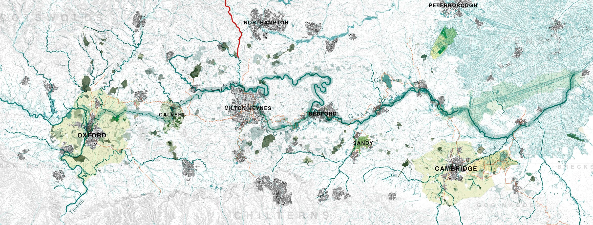
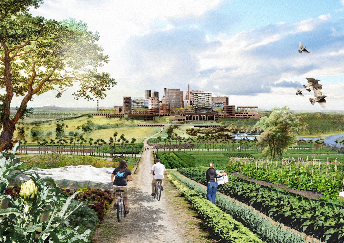
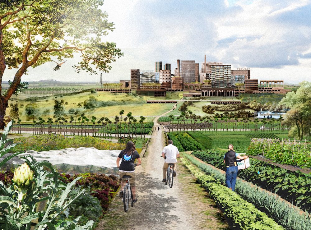
Test

Certified B Corporation — Adaptive Retrofit — Humanising Infrastructure — Making better places — Architecture — Public Realm — Spatial Strategy — Creative Reuse — Urban Transformation — Decarbonisation —

A 100-mile landscape from Oxford to The Wash

Ten years ago, the Architects Journal published 5th Studio’s proposal for a new ‘City in a Garden’ at Calvert, the point where HS2 and East-West Rail intersect. That thinking developed into research for the National Infrastructure Commission.

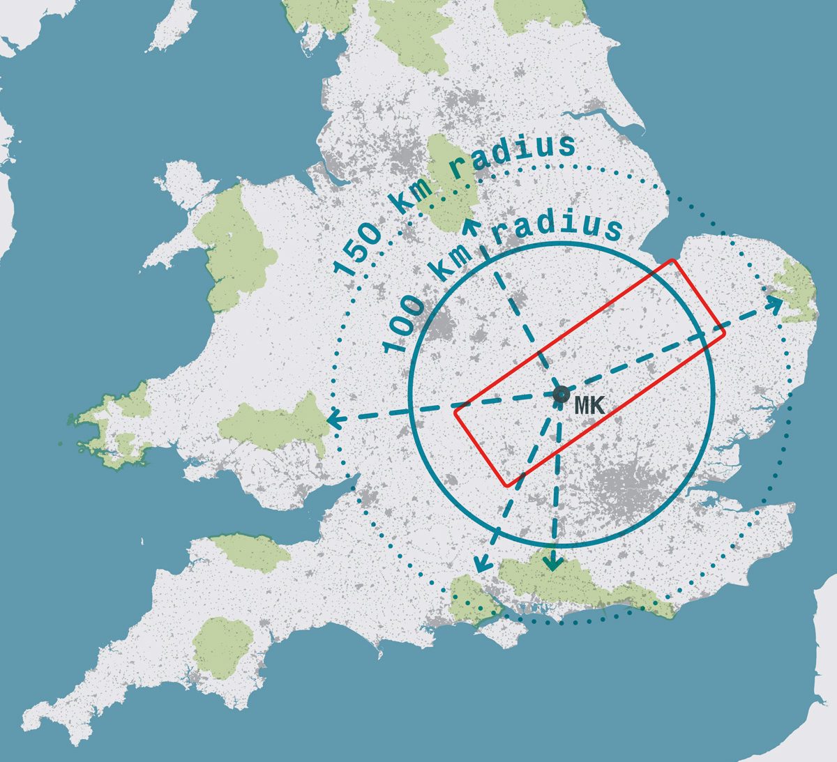
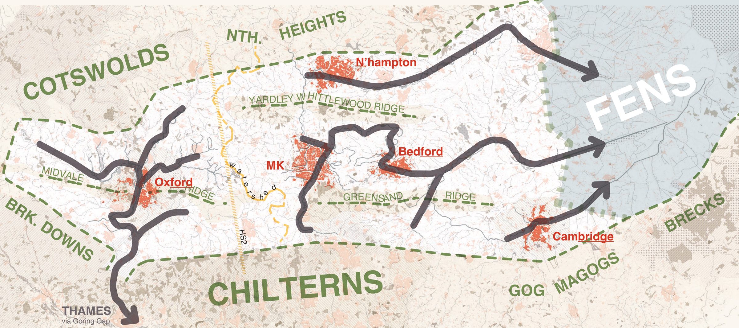
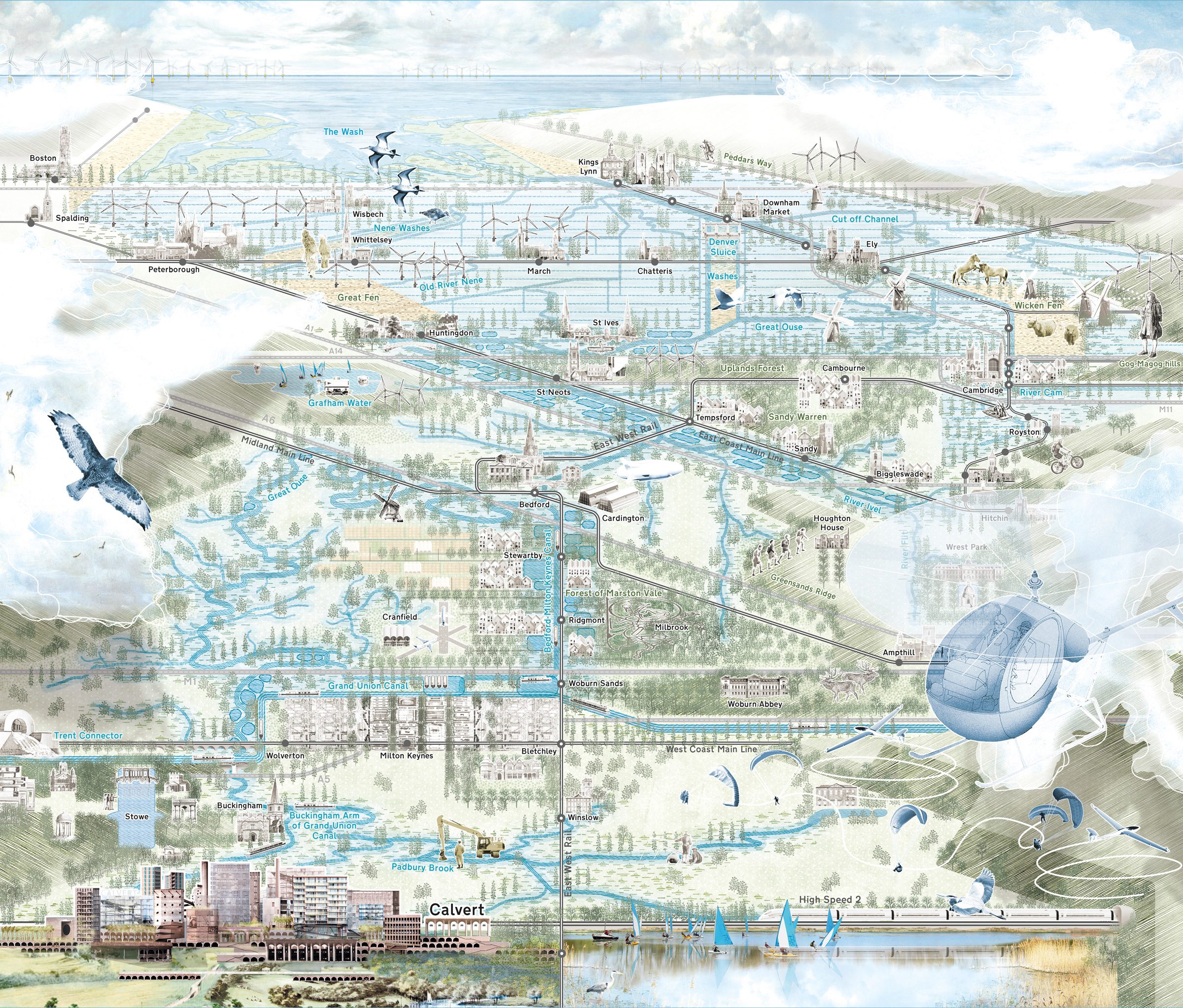
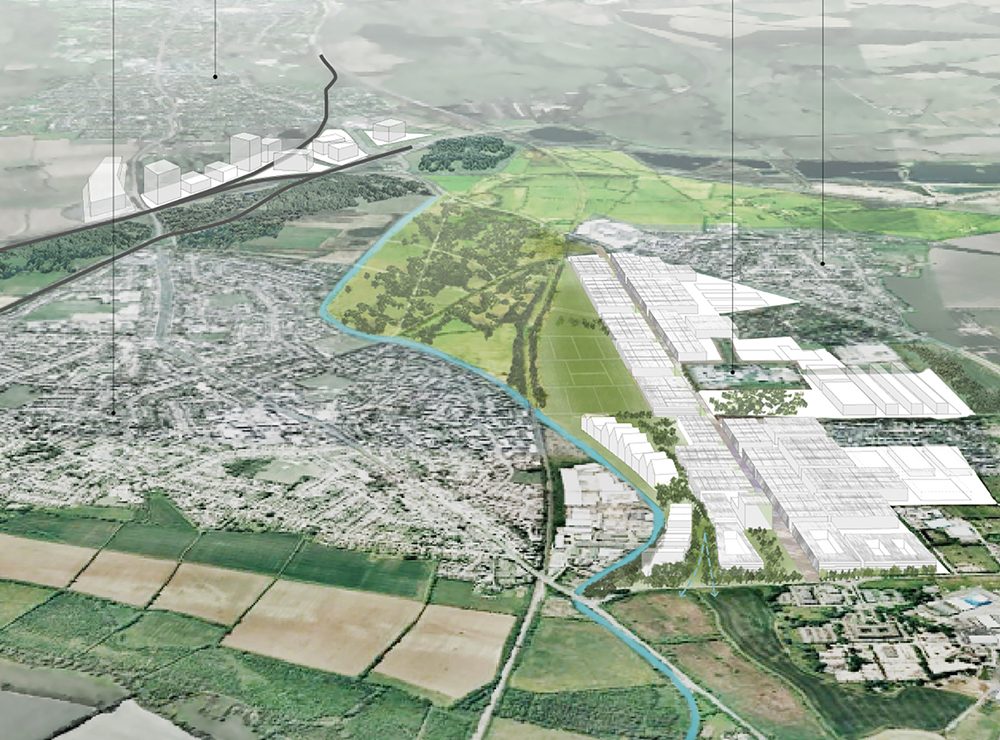
Our 2017 spatial study identified how sustainable development could be planned in the Arc – a crescent of land connecting Oxford and Cambridge – exploring a range of typologies for growth in appropriate places, supported by good transport and social infrastructure.

Political consensus is forming around the idea that the relatively productive towns and cities in the Arc are where national economic growth will fall, yet no available mechanism for regional planning exists and, with a government reluctant to intervene in what it regards as a task for housebuilders, it has been hard to find commissioners for spatial thinking at this scale. The consequence of poorly planned growth is evident: land suitable for building has been snapped up and used inefficiently for low-density housing. The resulting sprawl reinforces the sense of loss regarding the natural world and drives antipathy to further growth.

Draw a 100km diameter circle centred on Milton Keynes and it will capture the highest population density in Europe – about 22 million people. To reach the edge of one of Britain’s National Parks, that circle needs to expand to 150km in diameter. The highest density of people on our continent resides at the furthest distance from any large-scale natural landscape.

Water is the resource that will define this century. Lack of water threatens a sustainable future. Not a single reservoir has been built in the past 30 years and the East of England faces projected water shortages of 800 million litres a day – a third of the region’s water usage – by 2050. Water scarcity is at odds with growth ambitions in the Arc: the environment Agency has objected to further development in Cambridge until the water issue is resolved.

As one of the world’s most nature depleted countries, the UK faces an unprecedented crisis, fuelled by the climate emergency and biodiversity collapse. The State of Nature survey compiled by conservation organisations including the National Trust last year established that UK biodiversity has declined by an average of 19% since recording began in the 1970s; 43% of bird species and 33% of amphibians and reptiles are in decline.

Wicken Lode, Wicken Fen, © Copyright Hugh Venables

Daily news stories confirm the degrading of our environment, yet there is little sign of action at an appropriate scale and urgency. Government has, so far, chosen not to take the commanding lead that would respond to such a national emergency. For individuals, the situation can feel hopeless: we struggle to summon personal and local action equal to the enormity of the challenge.

Set against this bleak picture is the growing need for dedicated space for the new biodiversity net gain requirements, and for decarbonising investment at scale. On the ground, there are hundreds of inspiring bottom-up initiatives, including the Wildlife Trust’s Great Fen habitat restoration project, the Marston Vale Canal, which will link the Grand Union Canal to the River Ouse, and the National Trust’s Wicken Vision. Natural England’s Local Nature Recovery Strategies promise a new locally-owned system to plan nature recovery collaboratively.

But, while significant, even these projects are not equal to the challenge: how can they be aggregated and scaled up into a more ambitious framework for long-term strategic change?

While the landscape between Oxford and Cambridge is not be an easily experienced, functional territory at present, it has a unity at a geological level as the drainage basin from the Chilterns and the Cotswolds out to The Wash. Towns and cities in this landscape are characterised and shaped by their relationship to the great rivers within the basin.

The approach to Ely is always dramatic. The city and its cathedral loom at first faintly through the blue haze of the Fens, distinguishable as a whiter shade of pale. As you draw closer, the whole island shimmers like a mirage or a UFO that has just landed, and as the cathedral spire comes into focus, the place seems poised to take off again. Even the moated allotments, with their lowly huts like outside privies, derive an air of grandeur from their own row of boundary poplars, reaching for the heavens and striping them with long shadows.

This is a holy island, no less striking than Mont Saint-Michel, and no less holy, set off by the graphic flat horizon, rising out of the deep brown earth beneath a sea-blue sky. It dominates the most mysterious landscape in Britain, full of water and odd corners that can still be hard to reach, then let alone find.

As Daniel Defoe put it when he surveyed the Fens from a safe distance at the top of the Gogmagog Hills in 1724: “All the water of the middle part of England that does not run into the Thames or the Trent, comes down into these fens”

Extract from Waterlog, A Swimmer’s Journey Through Britain, by Roger Deakin

A 100-mile landscape from Oxford to The Wash

We propose a new kind of National Park – conceived at the scale of the region’s entire watershed – that can agglomerate these projects and catalyse many others to achieve more from the sum of the parts. The proposition establishes the space needed to address the grand challenges we face in the region, from decarbonisation to nature recovery. In one of the most nature-denuded areas in Europe, it will grow new public and wilderness spaces over time and at scale.

Britain’s National Parks have been designated around naturally occurring contiguous landscapes such as Eryri (formerly Snowdonia) or the Lake District. East Anglia does not have the same picturesque ready-made wilderness, yet – as the recently established Broads National Park shows – there is potential for dramatic wild beauty and rich biodiversity in these flat landscapes, where often there is a complex and filigree relationship between the natural and the man-made.

Towns and cities in the Arc are shaped by their relationship to their rivers; a National Park in the Arc would be animated and irrigated by bodies of water, both natural and artificially created. Water will lie at the centre of the new park’s creation.

The world’s most environmentally valuable chalk streams lie in the Arc and are on the point of collapse. Over the past century, the UK has lost 90% of its wetlands. Wetlands make up only 3% of the UK but are home to about 10% of all our wildlife species. Not only are they vital for the species that remain, they are also one of the most effective carbon sinks we have.

This is not a national park established around preservation, but one that aligns prospective bottom-up action with national impact. In exchange for better-planned growth, the park establishes a structure for defining where growth will not happen, as an active, qualitative version of the Green Belt. In addition to extending biodiversity and opportunities for leisure, the park will offset planned growth, making space to absorb carbon and address both flood and drought through the conveyance and storage of water. Rather than seeing landscape as the ‘ground’ and development as ‘the figure’, the park reveals the underlying singularity of the landscape as the powerful object.

Big infrastructure projects such as East-West Rail and the planned new Fen reservoir come with substantial budgets for landscape. All too often, the infrastructure project is built to solve a particular problem and landscape is thought of as an even overlay to ameliorate and disguise the solution.

But what if the infrastructure itself introduced its own kind of logic and beauty? As Ken Worpole argues in his essay Strangely Familiar in the East London Green Grid Primer: “It was once said of artists that they make the familiar seem strange; today, the work of environmentalists is perhaps to make what has now become strange seem familiar and loved again… landscapes of all types {create} the basis for individual and collective cultural identity, and landscape, conservation and enhancement {lie} at the centre of cultural policy.”

In turn, each development site is expected to deliver a portion of open space, yet the application of planning ratios can often lead to every site becoming suburban in density and in the resulting relationship between built form and landscape. What if (as we demonstrated at Calvert) the development is dense and urban, but contributes to and opens onto adjacent landscape which is truly ‘country’?

A great public landbank will not only assemble land over time (mirroring the successful processes used by, for example, the National Trust at Wicken). Uniquely, it will not just conserve, but create innovative spaces to experiment with new forms of land and water management, carbon sequestration and rewilding.

This will be a multipurpose landscape: a place for leisure that also collects water; an impenetrable landscape and a landscape for human occupation; a landscape to broaden natural diversity and one to provision the settlements within it. In terms of the latter, not least through food production: half of the UK’s most fertile agricultural land is in the fens, providing a fifth of the nation’s crops and a third of its vegetables. A tenth of all water in the region is used by agriculture, so agriculture needs to be integral, not oppositional.

Proposal for a continuous accessible waterway and watershed park from Oxford to The Wash (orientation rotated 35° clockwise from north)

From HS2 to LTNs, the age of consensus around infrastructure has broken down: in an age that needs more infrastructure to support energy transition and tackle grand challenges, it is now incumbent on all of us as designers to act as advocates for our projects. If we expected three public goods from every pound of investment we could perhaps sew public services back into popular imagination, but to do that we need to accept that heavy engineering and development can not just be technical, cheap and pragmatic: they have to have cultural resonance.

The UK is low on the table of G20 nations in terms of investment into its public fabric; Whitehall jealously holds the reins and writes the rules. Away from Westminster, local power is fragmented - the Ouse watershed falls into the patches of 5 water companies and at least 26 local authority areas. Each one of those local authorities has its own fragmentation: Cambridge has a Mayoral Combined Authority, a County Council, the Greater Cambridge Partnership and the City Council. With that amount of division, who speaks for big ideas? The Government has initiated a search for a new National Park: let’s build one where it is most needed.

The proposed new city at Calvert in its park setting.

WESTERN PARKLANDS

Calvert lies at the western watershed of the Ouse catchment. From here, Padbury Brook flows east to the River Ouse and the derelict Buckingham Arm of the Grand Union Canal. The River Ray flows to the west to meet the mysterious wetland of Otmoor and the Cherwell and Thames.

Extensive public land ownerships – including HS2 and the Ministry of Defence – offer space to establish and shape new places and to turn up the contrast between the built and the unbuilt. Our proposal for a new city at Calvert was to establish it in a new productive, parkland setting.

MARSTON VALE

The volume on Bedfordshire in Hoskins’ The Making of the English Landscape begins: ‘There is little that would immediately attract the casual observer to Bedfordshire’. Yet the area between Milton Keynes and Sandy has the potential for landscape restoration at scale.

The flooded brick pits of Marston Vale create a man-made environment that is important for nature. Two remarkable community projects have been working for years and need greater support – one to create a new forest on the clay uplands, and another to establish a long-imagined navigable canal to link the River Ouse to the Grand Union Canal.

This will enable narrowboat living and towpath activity and fill a gap in the waterways network. The opportunity is to swap piecemeal development in favour of testing better relationships between development, infrastructure and new landscape, drawing on local traditions of model farms and manufacturing villages, as well as Cranfield University’s Centre for Agricultural Innovation.

Axonometric of mixed development around the new station at Stewartby. A version of this drawing was published in our 2017 study for the National Infrastructure Commission.
View of our proposed multipurpose reservoir – the first in a generation – at the intersection of the River Cam and the Ouse.

THE FENS

North of Cambridge, the landscape gives way to the Fens – largely at or below sea level – and some of the most productive arable land in the UK. Intensive agriculture, energy generation and nature conservation vie for space. Here, the park amplifies ongoing work to restore the area’s wetlands and rediscover the rich pre-enclosure landscapes.

Wicken Fen is 125 years old and one of the most species-rich places in the country. The National Trust has long-term plans to extend the fen into Cambridge, open up walking and cycling routes and convert monocultural farmland into wild countryside.

This vast area plays a pivotal role in flood storage and water management. Anglian Water plans a new reservoir, the first in a generation, in a remote Fenland location fed by the Ouse system. We suggest a better location, where it can be truly multifunctional, at the confluence of the Rivers Cam and Ouse. Here it can be linked to a northern extension of the Wicken project and accessed and enjoyed for leisure by the railway and existing cycle links to Cambridge and Ely. This is in the true spirit of Grafham Water – the last reservoir to be constructed in the UK and the first to be explicitly planned to play multiple roles beyond water storage.

CONTACT

studio@5thstudio.co.uk

recruitment@5thstudio.co.uk

LONDON Unit 14 21 Wren Street London WC1X 0HF t +44 (0)20 7837 7221 View on Google Maps

CAMBRIDGE Darkroom Gwydir Street Cambridge CB1 2LJ t +44 (0)1223 516009 View on Google Maps

OXFORD 4 Hill Top Road Oxford OX4 LPB t +44 (0)20 4582 5525